Best Landscape Photography Spots in Big Bend National Park

Location & Landscape
Big Bend National Park is located in remote West Texas along the Rio Grande River, which marks the border between the United States and Mexico. Since 1944, the park has protected over 800,000 acres of desert, mountains, and canyons in the northern Chihuahuan Desert. The Chisos Mountains stand out in the middle of the park, creating dramatic changes in elevation and terrain that influence the climate and lighting.The main park roads make it easy to reach many top photography spots. Ross Maxwell Scenic Drive takes you to desert overlooks like Mule Ears Overlook and Santa Elena Canyon. Grapevine Hills Road leads to the Balanced Rock Trailhead, and Chisos Basin Road climbs into the mountains, giving access to viewpoints such as the Window View Trail. The dry climate brings bright sunlight, bold desert colors, and long shadows at sunrise and sunset. Winter and spring usually offer the clearest air for distant views.
Top Photo Opportunities
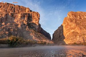
Santa Elena Canyon Trail Viewpoint: The viewpoint on the Santa Elena Canyon Trail is one of the most famous sights in Big Bend National Park. After a short walk from the trailhead, you reach the Rio Grande River, where tall limestone cliffs rise sharply above the narrow canyon entrance. The river bends into the canyon, drawing your eye toward the high walls that shape the scene. In the early morning or late afternoon, sunlight brightens the cliffs and highlights the difference between the sunlit rock and the shaded canyon. Photographers can shoot from the riverbank or climb the first part of the trail for a higher view of the canyon entrance.Sotol Vista Overlook on Ross Maxwell Scenic Drive: Sotol Vista Overlook gives visitors some of the widest views in the park. Found along Ross Maxwell Scenic Drive, this high spot looks west toward far-off desert ridges and volcanic formations. From here, photographers can capture layers of desert hills stretching into the distance, which works well for both telephoto and wide panoramic shots. At sunset, the light casts long shadows and warms up the ridges, making this overlook a favorite place to visit during the golden hour.
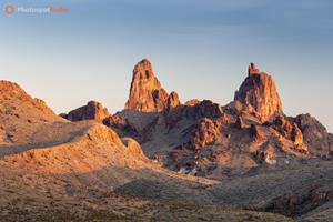
Mule Ears Overlook on Ross Maxwell Scenic Drive: Mule Ears Overlook gives you a clear view of the twin volcanic spires called Mule Ears Peaks. From the roadside pullout, the peaks stand out above the desert plain and draw your attention in the open landscape. In front, you’ll often see desert grasses, ocotillo, and sotol plants, which add texture and depth to wide-angle photos. At sunrise or sunset, warm light colors the volcanic rocks, and long shadows stretch across the desert. The open view from the overlook makes it easy for photographers to frame the peaks against the sky or distant mountains.
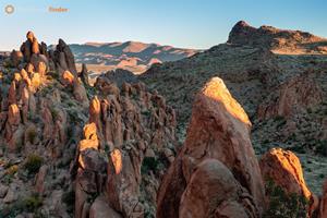
Balanced Rock Trail, Grapevine Hills: The Balanced Rock Trail in the Grapevine Hills takes you to a unique rock formation balanced on a narrow stone base. The trail is a short walk from the starting point, winding through weathered granite boulders until you reach a viewpoint where the rock stands out against the sky. Many photographers like to shoot the rock from below to bring out its dramatic shape and size. In the late afternoon and at sunset, the light brings out the granite’s texture and the colors of the desert slopes, making the warm rock stand out against the sky.
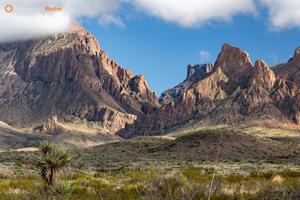
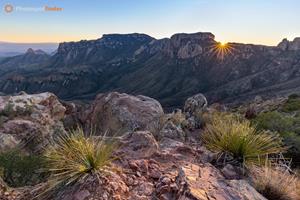
Lost Mine Trail Ridge Viewpoint: The ridge viewpoint on Lost Mine Trail offers some of the best high-up views of the Chisos Mountains and the desert basin below. As you hike, the trail leads through woodland and then opens up to a ridge with mountain peaks stretching out to the horizon. From here, photographers can take wide shots of Casa Grande Peak and the far-off desert valleys that reach toward Mexico. When the sun sets, side lighting highlights the ridges’ texture and adds depth to the mountain scenery.
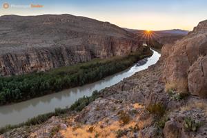
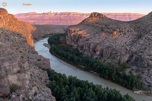
Rio Grande Village Nature Trail Hilltop Overlook: From the hilltop overlook on the Rio Grande Village Nature Trail, you can see the wide floodplain of the Rio Grande and the far-off Sierra del Carmen mountains. After a short climb, you reach a spot where the river and desert plants spread out below you. At sunrise, soft light fills the valley, and at sunset, the mountains glow with warm colors. The open sky and low light pollution also make this hilltop a great place for stargazing and astrophotography.
Photography Considerations
When photographing Big Bend National Park, try to include desert plants like ocotillo or sotol, or interesting rock formations in the foreground. These details help guide the viewer’s eye toward the distant peaks, canyons, or ridges. Use a wide-angle lens to capture sweeping desert views, and switch to a moderate telephoto lens to bring distant mountain layers closer or highlight features like Mule Ears Peaks. A tripod is useful during sunrise and sunset when exposures become longer and light levels drop. Polarizing filters can deepen the desert sky and reduce glare on rock surfaces, while neutral density filters allow long exposures along the Rio Grande. Because the park is recognized as an International Dark Sky Park, photographers may also bring fast wide-angle lenses for night photography and Milky Way compositions from open viewpoints.Visitor Tips & Key Notes
Big Bend National Park is very remote, and getting from one photography spot to another can take a while. Before heading out to explore the park’s scenic drives and trailheads, make sure to plan your fuel stops, bring enough water, and allow plenty of travel time. Temperatures also change a lot depending on where you are—expect cooler weather in the Chisos Basin and much hotter conditions on the desert floor.Lighting in the park changes a lot throughout the year, so the same spot can look completely different depending on the season, weather, or air clarity. In winter, mornings usually offer clear views across the desert, while summer monsoon storms can create dramatic skies over the mountains. You can use our interactive map, photos, and other resources to help plan your photo shoots. If you have tips or stories to share, please leave a comment to help others find new viewpoints in the park.