Best Photo Spots in Death Valley National Park
Death Valley National Park, spanning the California-Nevada border, is a prime destination for landscape photographers. The park offers a variety of unique photo spots, including Zabriskie Point, known for its surreal, striped hills and vibrant sunrises and sunsets; Badwater Basin, the lowest point in North America with vast salt flats creating striking geometric patterns; and the Mesquite Flat Sand Dunes, which feature rippled sandscapes perfect for dramatic shadow and light photography. With countless places to explore and photograph, this park is a landscape photographer’s dream. However, if you're short on time, here are a few easily accessible locations you won’t want to miss.
1. Zabriskie Point
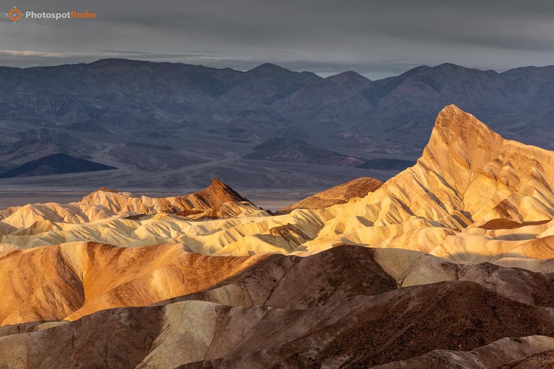
Zabriskie Point is a fantastic starting point for landscape photography in Death Valley. Just a 15-minute drive east on Highway 190 from the Furnace Creek Visitor Center, this spot is renowned for its surreal terrain of striped yellow and brown rocks and hills, sculpted by ancient water flows. This location, once covered by Furnace Creek Lake over 5 million years ago, offers dramatic views that change with the light.
For the best photos, visit at sunrise or sunset when the landscape comes alive with colors. The Manly Beacon, a striking geological formation named after a gold rush pioneer. Standing at an elevation of 823 feet, Manly Beacon commands attention with its distinctive shape and towering presence. It is especially captivating when photographed during sunrise or sunset, when the changing light enhances its textures and colors, creating a truly mesmerizing scene.
2. The Badwater Basin
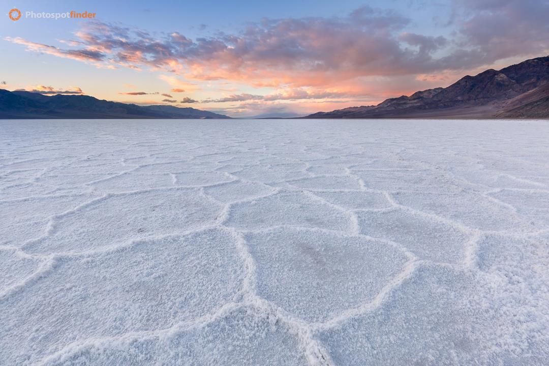
Next on our list is Badwater Basin, the lowest point in North America at 282 feet below sea level. A 30-minute drive south of Furnace Creek brings you to this vast expanse of 200 square miles of salt flats, remnants of an ancient lake that evaporated long ago. The ground here is a natural canvas of geometric salt polygons, which glisten and shift colors in the changing light.
The basin’s unique textures and patterns make it a perfect subject for creative compositions. A short walk from the boardwalk allows you to step onto the flats, offering endless possibilities for capturing the stark beauty of this otherworldly landscape.
3. Mesquite Flat Sand Dunes
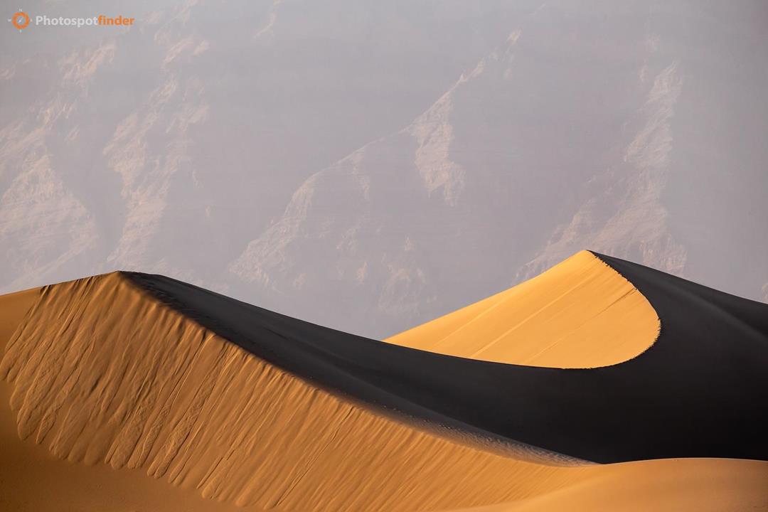
The Mesquite Flat Sand Dunes offer another iconic setting for landscape photography. Known for their rippled, curving dunes that seem to stretch endlessly, this area is both serene and dynamic. You’ll encounter three types of dunes here: star, crescent, and linear, each presenting its own photographic opportunities.
Easily accessible from the nearby parking area, the dunes have no marked trails, allowing you to roam freely and find the perfect vantage point. For striking photographs, visit at sunrise or sunset when the play of light and shadow creates a dramatic contrast on the dunes. A telephoto lens can be particularly effective for isolating subjects and capturing the subtle textures and patterns of the sands.
Death Valley National Park is a treasure trove for photographers, offering a diverse range of landscapes to explore. Be sure to bring your camera and a sense of adventure to capture the park’s incredible beauty.
If you’re planning a trip to Death Valley National Park and searching for the top spots to enhance your landscape photography portfolio, you’re in the right place. This guide will help you explore the must-visit locations for breathtaking shots. Don’t forget to check out our location map and photos map for more details and precise coordinates of every photo spot mentioned.